
Sources Around a Sun Prairie Block
Public sources describe parcels, registrations, historic listings, and civic contacts, not a full roster of Sun Prairie neighbors. Start with the source that matches the question. Prairie Map gives spatial context. Access Dane gives parcel and owner facts. MyVote helps a person check their own registration or find election information for an address. Historical collections show the block at an earlier date. Community programs offer a safe contact layer without exposing private member lists.
| Source | What It Shows About a Block | Access |
|---|---|---|
| Prairie Map | Parcel shapes, streets, and neighborhood layers | Free city map |
| Access Dane | Owners, parcel and billing addresses, land and tax facts | Free county portal |
| MyVote Wisconsin | Polling, ballot, and a person's own registration | Official state portal |
| Neighborhood Navigators | Public community contact path | City program |
| SPHLM collections | Dated directories, plats, tax books, news, and photos | Online or staff request |
An owner name proves a property-record relationship. It may represent a person, business, estate, or trust. A bill may go elsewhere, and even a matching mailing and parcel address does not name each occupant. Keep owner, mailing contact, registered voter, directory listing, and resident distinct. That discipline stops a reasonable block search from becoming a false household profile.
See Sun Prairie Neighbors Spatially
The Sun Prairie GIS hub and Prairie Map provide the city view. Search or zoom to the subject address, click its parcel, then work outward to lots sharing a side or rear line and those across the street. Visible GIS data includes property street number, street name, and billing street address, though the complete field inventory was not confirmed. Record only facts shown by the official app.
The flow is simple: address → subject parcel → nearby parcel shapes → parcel IDs → county owner records. A shared line establishes adjacency, not a neighboring household. Roads, multi-unit lots, common space, and vacant land can change what “next door” means. Save the view date because GIS data changes.
Confirm Sun Prairie Parcel Owners
After the map sets the block, Access Dane adds the county record. Search by street address or parcel number. Results can show the PIN, municipality, legal description, owner, primary or situs address, billing or mailing address, assessment, acreage, tax facts, and recorded-document links.
- Locate the starting address in Prairie Map and note its shape.
- Click only the nearest parcels and copy their parcel IDs.
- Open each ID in Access Dane and record the owner as dated evidence.
- Keep situs and billing addresses separate. Neither is an occupant roll.
For a whole road instead of one block, follow the Sun Prairie street directory. The official county form pictured below offers owner, address, parcel, PLSS, and plat routes.
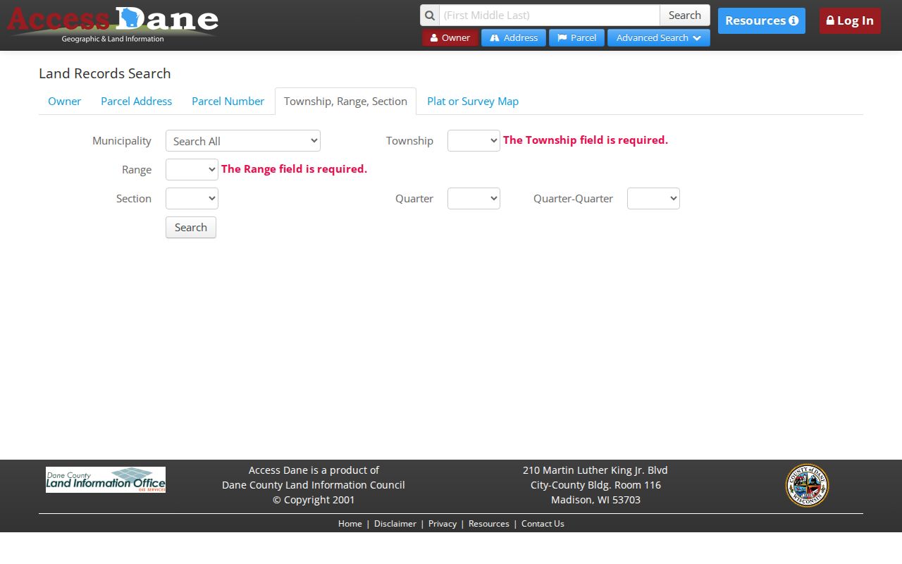
Those routes help recover a parcel without claiming that an indexed owner is a resident.
Sun Prairie Neighborhood Names
A city community-survey appendix uses names such as Angel Park, Arabian, Bird Street East, Cannery Square, Downtown, East Side, Fox Point, Hunters Creek, Patrick Marsh, Prairie Lakes, Royal Oaks, West Prairie, and Westwind. These labels help describe a place. They are not a verified list of homeowners associations, and they do not prove that a home belongs to a private group.
The city’s Neighborhood Navigators program is the documented public contact layer. No full private member directory was found. When the aim is to greet or reconnect with your neighbors, ask a public program or known group to pass on a note. A library, museum, church office, school alumni channel, or civic group may relay a respectful message without confirming a private address.
Keep the label and the government boundary in separate fields. “Downtown” or “Patrick Marsh” may describe how survey respondents understand their area, while a parcel record supplies the municipality and legal description. A Sun Prairie mailing label may also reach outside the incorporated city. That distinction matters when a civic question belongs with the City Clerk, a nearby town, Dane County, or a postal source. The neighborhood name is useful context, but the parcel and source date decide jurisdiction.
City GIS
Parcel and neighborhood map help
608-825-1170
City Clerk
Records routing and civic information
608-837-2511
Public Library
Local databases and research help
608-825-7323
Election Records and Sun Prairie Neighbors
MyVote Wisconsin has two distinct routes. Its name search asks for first name, last name, and date of birth so a voter can view their own registration. Its address search gives polling, ballot, and election information. It is not a public list of all registered people at nearby homes. Older activity beyond ten years may need a WEC request, but the current file schema and fee were not verified.
For public election research, contact the Wisconsin Elections Commission or Sun Prairie City Clerk and describe the record. Clerk inspection and written records channels may be available, subject to redaction. Confidential electors and Safe at Home users have address protection. Do not gather dates of birth, voter IDs, voting-history detail, or protected addresses while studying a block.
Note: A MyVote address result describes elections for a place; it does not name the Sun Prairie neighbors who live there.
Meet Past Sun Prairie Neighbors
The Sun Prairie Historical Museum & Library can reconstruct the block at a chosen date. Holdings include phone books from the 1920s to 2007, tax books from 1868-1949, plats, newspapers, school and church material, and assessor descriptions and photos from the 1960s and 1970s. Physical research is paused or appointment-only while the archive is stored, so call 608-825-0837 or email museum@CityofSunPrairie.com first.
For an early block, modern numbers will fail because the village had no street or building-number system before 1950. Start with the parcel’s legal description and old landholder. Compare a plat, tax book, dated newspaper, and the 1899 or 1905 Sanborn maps. County plat books from 1873-2001 sometimes contain directories that locate land or relatives, though the run is incomplete.
Historic sources describe past neighbors at a stated date. They do not reveal the present household.
SPHLM’s Benisch and Aldrich obituary and article file reaches beyond the city into eastern Dane County. Check each item’s stated place before calling a named person a Sun Prairie neighbor. School yearbooks cover 1936 through 1941 and 1944 to the present, with earlier Maroon and Gold issues and school newspapers from 1904 through 1932. These sources can connect classmates and community groups to a dated place, but they are not block rolls. Church directories and local business records work the same way: they show a documented link at a time, not a private modern address.
Choose Official Neighbor Records
Official rolls and commercial neighbor tools answer different questions. Government and archive sources identify the custodian, record type, date, and limits. Commercial compilations may merge names, old addresses, and relatives without showing how a claim was made. They should not replace a parcel, map, or dated archive check.
| Source type | Useful for | Key limit |
|---|---|---|
| City or county record | Parcel, owner, map, permit, civic facts | An owner or applicant may not occupy the site |
| Historical archive | A dated block, building, or community link | Not current residence evidence |
| Commercial compilation | A possible lead only | Source, date, and identity may be unclear |
When a portal fails, call the custodian, inspect records in person, send a narrow request, or ask the library or museum about old material. Those routes retain context and give a correction path.
Wisconsin Public Records Law also supports a focused fallback. Ask the correct Sun Prairie custodian for a record type, address or parcel, and a bounded date range. Building Inspection may hold permits or violations; Planning keeps development material; Engineering and GIS keep map records. The city portal can submit and track a request, and in-person, mail, email, phone, or inspection channels may fit the record. A narrow request is easier to locate and leaves room for lawful redaction. The law calls for a response as soon as practicable and without delay, not within one fixed statewide number of days.
Protect Your Sun Prairie Neighbors
A neighbor lookup should stop where the public purpose ends. Utility accounts, delivery records, library patron files, victim details, juvenile files, and protected addresses are not block directories. Court records may be sealed or redacted. An assessor roll does not list renters or all household members. A no-result may reflect a spelling issue, move, different municipality, update lag, or legal protection.
Wisconsin Safe at Home gives eligible survivors a substitute legal address and forwards mail. Applications use an Application Assistant and go by mail or fax, not email. Confidential electors also receive safeguards. Never try to defeat them through deeds, maps, election files, or another agency.
Record a portal’s access date and the date on the record. Current parcel, permit, and election facts can change, while a static street map or archive item remains a snapshot. If two sources disagree, preserve both labels and ask the custodian to explain the update cycle. Do not fill a missing renter, unit occupant, or protected person with an inference from a billing address, deed return address, court file, or commercial compilation.
Lawful use. Research Sun Prairie neighbors for civic interest, history, reconnection, or safety. Never watch, intimidate, expose, or harass anyone.